
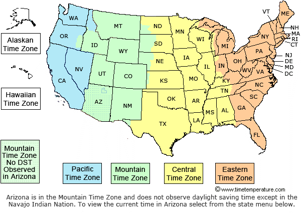
Boundary Line Between Central and Mountain Time Zones in the United States
United States Time Zone Boundaries
Montana-North Dakota - Beginning at the junction of the Montana-North Dakota boundary with the boundary of the United States and Canada southerly along the Montana-North Dakota boundary to the Missouri River; thence southerly and easterly along the middle of that river to the midpoint of the confluence of the Missouri and Yellowstone Rivers; thence southerly and easterly along the middle of the Yellowstone River to the north boundary of T. 150 N., R. 104 W.; thence east to the northwest corner of T. 150 N., R. 102 W.; thence south to the southwest corner of T. 149 N., R. 102 W.; thence east to the northwest corner of T. 148 N., R. 102 W.; thence south to the northwest corner of 147 N., R. 102 W.; thence east to the southwest corner of T. 148 N., R. 101 W.; thence south to the middle of the Little Missouri; thence easterly and northerly along the middle of that river to the midpoint of its confluence with the Missouri River; thence southerly and easterly along the middle of the Missouri River to the midpoint of its confluence with the western land boundary of Mercer County; thence south along the western county line of Mercer County to the southwest boundary; thence east and south along the southwestern county boundary of Morton County to the intersection with the boundary with Sioux County; thence west and south along the northern boundary of Sioux County to the center of State Highway 31; thence south along the center of State Highway 31 to the State border with South Dakota; thence east along the southern boundary of Sioux County in the middle of the Missouri River.
Note: The boundary line between the central and mountain time zones was revised effective November 7, 2010 when the Department of Transportation moved all of Mercer County, ND to the central time zone.
South Dakota - From the junction of the North Dakota-South Dakota boundary with the Missouri River southerly along the main channel of that river to the crossing of the original Chicago & North Western Railway near Pierre; thence southwesterly to the northern boundary of Jones County at the northeast corner of the NE 1, Sec. 6, T. 2 N., R. 30 E.; thence west along the northern boundary of Jones County; thence south along the western boundaries of Jones, Mellette and Todd Counties to the South Dakota-Nebraska boundary.
Nebraska - From the junction of the west line of Tripp County, South Dakota with the South Dakota-Nebraska boundary west along that boundary to the west line of R. 30 W.; thence south along the range line between Rs. 30 and 31 W. to the southwest corner of sec. 19, T. 33 N., R. 30 W.; thence easterly along section lines to the northeast corner of sec. 29, T. 33 N., R. 30 W.; thence southerly along section lines with their offsets to the northeast corner of sec. 17, T. 32 N., R. 30 W.; thence westerly along section lines to the northwest corner of sec. 18, T. 32 N., R. 30 W.; thence southerly along the range line to the southwest corner of T. 31 N., R. 30 W.; thence easterly along the township line to the northeast corner of T. 30 N., R. 30 W.; thence southerly along the range line to the southwest corner of T. 29 N., R. 29 W.; thence westerly along the township line to the northwest corner of sec. 4, T. 28 N., R. 30 W.; thence southerly along section lines to the southwest corner of sec. 33, T. 28 N., R. 30 W.; thence easterly along the township line to the northeast corner of sec. 4, T. 27 N., R. 30 W.; thence southerly along section lines to the southwest corner of sec. 22, T. 26 N., R. 30 W.; thence easterly along section lines to the southeast corner of sec. 24, T. 26 N., R. 30 W.; thence southerly along the range line to the north line of Thomas County; thence westerly along the north line of Thomas County to the west line of Thomas County; thence south along the west line of Thomas County to the north line of McPherson County; thence west along the north line of McPherson County to the west line of McPherson County; thence south along the west line of McPherson County to the north line of Keith County; thence east along the north line of Keith County to the west line of Lincoln County; thence south along the west line of Lincoln County to the north line of Hayes County; thence west along the north lines of Hayes County to the west line of Hayes County; thence south along the west line of Hayes and Hitchcock Counties to the Nebraska-Kansas boundary.
Kansas-Colorado - From the junction of the west line of Hitchcock County, Nebraska, with the Nebraska-Kansas boundary westerly along that boundary to the northwest corner of the State of Kansas; thence southerly along Kansas-Colorado boundary to the north line of Sherman County, Kansas; thence easterly along the north line of Sherman County to the east line of Sherman County; thence southerly along the east line of Sherman County to the north line of Logan County; thence westerly along the north line of Logan County to the east line of Wallace County; thence southerly along the east line of Wallace County to the north line Wichita County; thence westerly along the north line of Wichita County; thence westerly along the north line of Wichita County to the east line of Greeley County; thence southerly along the east lines of Greeley County and Hamilton Counties; thence westerly along the south line of Hamilton County to the Kansas-Colorado boundary; thence southerly along the Kansas Colorado boundary to the junction of that boundary with the north boundary of the State of Oklahoma.
Oklahoma-Texas-New Mexico - From the junction of the Kansas-Colorado boundary with the northern boundary of the State of Oklahoma westerly along the Colorado-Oklahoma boundary to the northwest corner of the State of Oklahoma; thence southerly along the west boundary of the State of Oklahoma and the west boundary of the State of Texas to the southeast corner of the State of New Mexico; thence westerly along the Texas-New Mexico boundary to the east line of Hudspeth County, Tex.; thence southerly along the east line of Hudspeth County, Tex., to the boundary between the United States and Mexico.
Municipalities on boundary line - All municipalities located upon the zone boundary line described in this section are in the central standard time zone.
Time Zone Boundaries in the United States
| CODE | UNITED STATES TIME ZONE BOUNDARIES | UTC OFFSET |
| AST | ATLANTIC STANDARD TIME | UTC - 4 |
| EST | EASTERN STANDARD TIME | UTC - 5 |
| CST | CENTRAL STANDARD TIME | UTC - 6 |
| MST | MOUNTAIN STANDARD TIME | UTC - 7 |
| PST | PACIFIC STANDARD TIME | UTC - 8 |
| AKST | ALASKA STANDARD TIME | UTC - 9 |
| HAST | HAWAII-ALEUTIAN STANDARD TIME | UTC - 10 |
| WST | SAMOA STANDARD TIME | UTC - 11 |
| CHST | CHAMORRO STANDARD TIME | UTC +10 |